New Zealand had been on our to-do list for some time, so we eventually committed to three weeks off work and booked the trip. Eleven months later, it finally rolled around. All holidays start with a journey: this one began with the longest commercial flight in the world, 16h40m from Doha to Auckland (17h50m on the return leg!), albeit with 6h30m from Manchester to Doha first. We were spoiled by an offer from Jack’s Flight Club which meant we picked up business class flights on Qatar for around £300 more than economy (rather than the usual £3000+!), so I’m forever in their debt and would obviously highly recommend them.

© Haydn Williams 2018

© Haydn Williams 2018
We landed in Auckland at 04:30, so with 7½ hours to kill before we could check in to our hotel room we took an unexpectedly-20km walk around the city before collapsing into bed (I’d had 2½ hours sleep in the previous 48 by this point!). Day two began with a fantastic breakfast at a cafe called Federal and Wolfe. I am now going to present something never-before seen in the ten-year history of this blog – a photograph of a meal I ate:

© Haydn Williams 2018
I hope you’ll agree that was worth breaking my own rules for – yes it did taste as good as it looks. We picked up the hire car then started South, stopping at Wairere Falls on the way. After a steep climb to the top of the falls we enjoyed the view across the valley, although it was bizarre to think that the first people to ever witness that sight did so only 750 years ago. New Zealand was first settled (by anyone, not just Europeans) around 1280. Before that there were absolutely no hominins there, which is a somewhat strange thought when you consider that by that point in Britain we’d already done Magna Carta, and the Tower of London had been standing for 200 years.

© Haydn Williams 2018

© Haydn Williams 2018
Onwards to Rotorua, entering the Taupo Volcanic Zone, “one of the most active volcanic areas in the world”. The justification for this title was first demonstrated to us at Waimangu Volcanic Valley. The tourist section of the valley is a stretch of about 3km of vents, lakes and thermal springs (out of a total 16km) which unexpectedly just blew up overnight in 1886, on what was previously geothermically-inactive scrubland. I love the idea of such huge features forming in a matter of hours, and I also love that we still don’t understand how they work. For example, every 38 days two lakes in separate craters swap levels and temperatures (they go up in one, and down in the other) and no-one has the faintest idea why. Science is great, but sometimes the fact that it’s utterly stumped is even more brilliant.

© Haydn Williams 2018
Next was Waiotapu Thermal Wonderland, which was actually very good despite the cringeworthy name. With greater mineral content than Waimangu, it displayed more vivid colours and was just a bit more Technicolour.

© Haydn Williams 2018

© Haydn Williams 2018
The next day was scheduled for the Tongariro Crossing, a high-level path traversing volcanic Mount Tongariro at a maximum height of 1886m. Unfortunately our crossing was cancelled due to bad weather – boo! All of the bus operators stop if the weather is bad, on the assumption that no-one will want to go up there, so you’ve no way of doing the one-way trip. The whole national park is a UNESCO World Heritage site though, so we went to the car park to get a photo next to the logo. That means I can now tick it off the list.

© Haydn Williams 2018

© Haydn Williams 2018
As an alternative we picked a road on the map which looked like it might be 4×4-worthy, and put the hire car through its paces. The Department of Conservation (DOC) website did mention that it was in “poor condition and unsuitable for cars“, but after 11km of bumping ever-downwards through plantation and native forest, we eventually reached Okupata caves. They’re accessed on foot from a river bed, and drop almost immediately downwards in to a dark abyss that defied our puny attempts at lighting it.

© Haydn Williams 2018
The next day was a drive to Wellington, along the very wiggly Whanganui river road. I wish I could have taken photos which do justice to the way this road clings to the mountainside high above the river with a distinct lack of safety barriers, but they all made it look very boring. The defining feature of this part of the world is blanket forest, and this theme was to continue on the South island.

© Haydn Williams 2018

© Haydn Williams 2018
Driving in New Zealand is very easy, since they’re on the correct (left) side of the road and a lot of the road signs are the same as in the UK. Our journey was thrown into temporary disarray though, when my mind was blown by a roundabout with five exits (all good so far…) and a train track running straight through the middle! That’s just not cricket.

© Haydn Williams 2018
As we headed South the weather started to turn, and by Wellington it was raining torrentially and blowing a gale. The South Island was taking the brunt of it though, with some areas having more than 440 mm of rain in 24 hours, washing away bridges and generally causing havoc. The ferry between North and South islands was also cancelled, leaving us to worry about whether we’d have no crossing the following day, or just a vomit-inducing one!

© Haydn Williams 2018
The weather gods were smiling the next morning, and after a pancake-flat crossing to the South island we jumped into a water taxi to the Bay of Many Coves resort in Queen Charlotte Sound, accompanied by dolphins for part of the journey. Never was a more relaxing place found, and we lowered the average age of the guests by about 20 years too.

© Haydn Williams 2018

© Haydn Williams 2018
The site is accessible only by boat, so the next day our transfer to Ship Cove was also marine in nature. Ship Cove was Captain Cook’s “favourite New Zealand base during his three voyages of exploration“, apparently. New Zealand was first ‘discovered’ by Europeans when Dutchman Abel Tasman got four of his crew killed in the first meeting between Maori and Europeans, and no Europeans ventured back for another 127 years until Cook arrived and mapped the entire coastline. At the memorial I learned that the official reason for Cook’s first voyage (1769) was to observe the transit of Venus from the South Pacific, to aid in calculating the distance to the sun. It seems that the part reading “search for riches in unknown lands” was a secondary set of orders opened only once the transit had been recorded.

© Haydn Williams 2018
From Ship Cove we ran 25km along the Queen Charlotte Track, one of many long-distance paths maintained to a very high standard by the Department of Conservation. There are hundreds of shorter tracks and natural points of interest which are well-signed, often have toilets and drinking water despite being in the middle of nowhere, and have plenty of free parking. In our case the parking at the end of this run was for boats, and we zipped back around past headlands and bays to the hotel, having somehow managed to pick up 850m of ascent and descent during the day’s very sunny seaside running.

© Haydn Williams 2018

© Haydn Williams 2018
Another night and we were reluctant to leave, but had an appointment to collect hire car number two. We quickly motored across to Abel Tasman National Park, and the stunning location of The Resurgence chalets via some lovely scenery on the way.

© Haydn Williams 2018

© Haydn Williams 2018
We had some kayaking scheduled the next day, and the sun which had appeared at the Bay of Many Coves continued to shine for our paddling trip.

© Haydn Williams 2018

© Haydn Williams 2018

© Haydn Williams 2018

© Haydn Williams 2018

© Haydn Williams 2018
On the move again 24 hours later, we drove to Punakaiki on the west coast, via a road described by our tour operator and NZ authorities as a ‘4×4 track’ – the Braeburn Track. This was one of the reasons we’d been provided with a 4×4, so we approached with eager anticipation. We weren’t disappointed.

© Haydn Williams 2018
OK, we were disappointed. But it was a lovely location, and definitely worth the diversion for the scenery if not for the off-road action. Arriving at Punakaiki we visited the Pancake Rocks and then I returned in the evening to photograph sunset. There were about eight other photographers there who had all had the same idea, so I set about trying to find something different.
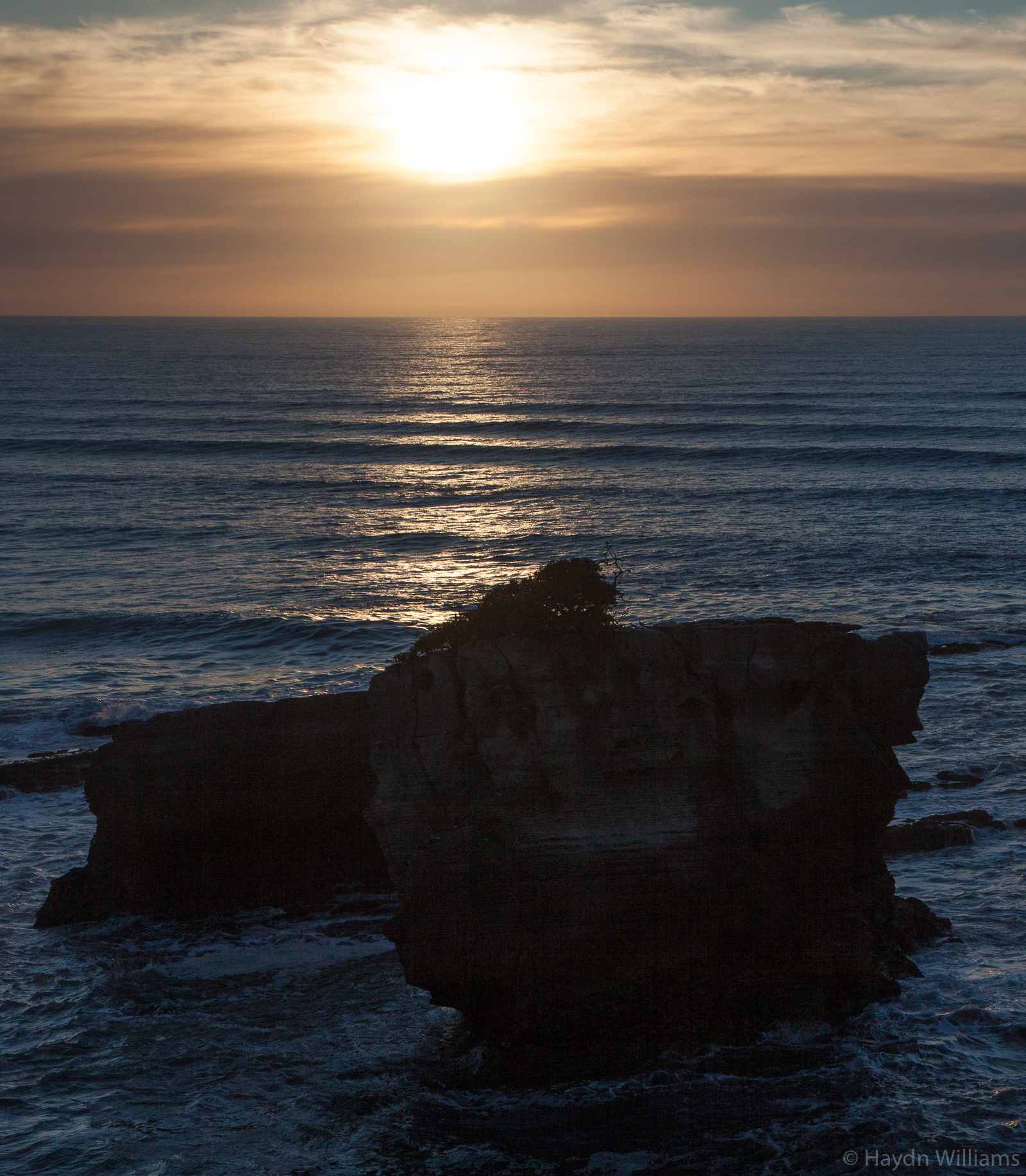
As sunset passed I was pleased to confuse them all by setting up my camera pointing into the air, on a footpath with no view and flanked by high bushes. I got the shot I wanted though, of the moon over harakeke (flax) bushes.

© Haydn Williams 2018
No travelling for the next day, and a well-deserved day off halfway through the holiday. That plan went out of the window with a walk up the Pororari River Track in the morning, and another non-tour-operator-sanctioned 4×4 track in the afternoon. This one took us up into the hills for 6km, gaining much height and also necessitating a “will we get through this?” inspection at one particularly bumpy point where the road traversed the river bed and several other vehicles had been abandoned. Fortunately the Rav4 performed better than I had perhaps previously given it credit for, and we careened our way to the top before doing another walk through forest to Cave Creek.

© Haydn Williams 2018
Southwards again in the morning, to the Okarito Lagoon (so lame I’m not even going to discuss it here) and then for a walk up to the Franz Josef glacier. It’s a bit of a beast when you reach it – unfortunately the walk is much farther now than in previous years as it retreats due to global warming (yes, I do realise the irony/hypocrisy of pointing this out in the same post that I catch the longest aeroplane flight on the planet).

© Haydn Williams 2018
An action-packed next day saw us hitting the rather massive Te Wahipounamu UNESCO World Heritage Site, thus meaning the only NZ one left for me to visit is the ‘sub-antarctic islands’, i.e. not going to happen! A long drive took us South and West, with lots of mini-stops on the way for points of interest.

© Haydn Williams 2018

© Haydn Williams 2018
We moved inland over the Haast Pass and along Lake Wanaka and Lake Hawea. Our stop for the night was Wanaka, which was pretty amazing. It has quite an alpine feel with ski areas, mountain biking, lake, etc., and is really chilled-out.

© Haydn Williams 2018

© Haydn Williams 2018

© Haydn Williams 2018
One of my most eagerly-anticipated ‘tramps’ (the kiwi word for ‘difficult walk’, although their definition of ‘difficult’ is perhaps questionable too) was up to the Rob Roy glacier. This is 58 km from Wanaka, with the second 30 km being on unsealed road, and the final 10km described as only suitable for high-clearance 4WD vehicles. A Rav4 is high-clearance, right?

© Haydn Williams 2018
The first river crossing was like a qualifier feature on a mountain bike downhill course – equivalent to the most difficult obstacle, to determine whether you’re game for the full run or should just retreat immediately. We made it successfully through that one, and the remaining eight posed even less of an issue. The walk up to the glacier was very enjoyable, and gets the “Tramp of the Trip” award from me. Over a swingbridge and up through mountain forest (not the thick lowland stuff which had been so prevalent on the entirety of the south island to date), past the avalanche warning signs and on to the glacier lookout point. It could be argued that I enjoyed it simply because I’m most at home in the mountains – I’m far more comfortable in the hills than at the seaside because I know how to identify and deal with mountain hazards, but you don’t usually see a shark attack coming. Anyway we ran back down the hill to the car by the same route, on enjoyable terrain and just beat the incoming drizzle. Lovely.

© Haydn Williams 2018

© Haydn Williams 2018

© Haydn Williams 2018

© Haydn Williams 2018

© Haydn Williams 2018
After Wanaka we had a change to the advertised schedule and decided on an impromptu night in Queenstown to make some of the travelling easier. The drive from Wanaka took us over the Crown Range Road, one of the highest passes in the country. I was a little confused when we passed what looked like a fence with hundred of bras hanging from it. Apparently that’s exactly what it was, though. Undistracted, we continued from 20-degree lakeside weather into sleet, and then onwards into snow as we settled into our Queenstown hotel room.

© Haydn Williams 2018
The snow continued overnight and made the next day’s drive to Te Anau (pronounced like Keanu, as in Reeves) even more scenic than usual.

© Haydn Williams 2018

© Haydn Williams 2018

© Haydn Williams 2018

© Haydn Williams 2018
Once there we boarded a boat across the most voluminous body of freshwater in the southern hemisphere (big lake) to the glow worm caves. The glow worms are actually the larval stage of the life cycle of the fungus gnat, but regardless of name they look very pretty arrayed around the walls and roof of the caves. Unfortunately you’ll have to take my word for it because photography wasn’t allowed. Sorry.
Channeling our inner OAP, we took a coach trip to Milford Sound the following day. I’ll confess that it was quite nice not to be doing the driving, and as we progressed along the scenic Milford Road towards the coast we were also treated to our first encounter with kea. These are the world’s only alpine parrot; clever and inquisitive, and prone to investigating things like cars and campervans by pulling bits off them. There used to be over 150,000 of them but the Kiwis persecuted them almost to the point of extinction in the second half of the last century. This was apparently to safeguard sheep stocks – the kea learned how to peck into the bodies of sheep to eat the fat-rich tissues from around their kidneys (while the sheep still wandered around the field munching grass).

© Haydn Williams
It’s pretty gruesome, but perhaps understandable when you think that the kea originally developed the tactic to feed off moa – these were massive flightless birds which were made extinct within 100 years of the maori first discovering New Zealand. In the sudden absence of my natural prey, I think I’d turn to lamb and mutton if some nice European settlers introduced them instead.
Our fat-rich tissues intact, we continued to Milford Sound, named after Milford Haven by the Welshman who discovered it (well, discovered it for Europeans – the maori were already there). A glacial fjord with surrounding peaks rising 1600m from the shore, it provided our first and only glimpse of Fiordland Crested penguins.

© Haydn Williams 2018

© Haydn Williams 2018
We also heard someone asking the guide whether New Zealand had any tigers – unsurprisingly we were safe on that front, but what I hadn’t realised prior to the trip was just how many species we (the British) had introduced. Rabbits, stoats, weasels, hedgehogs, ferrets, sheep, goats, possums (OK, that was the Australians, but it’s all the Commonwealth, right?), red, wapiti, fallow, white-tailed, sika, sambar and rusa deer, rooks, greenfinches, sparrows – so many, in fact, that there is an entire Wikipedia page about it. The scale of the operation to now try and eradicate some of the most damaging invaders is really quite astounding, with trailside traps being a constant companion throughout our travels.

On the return leg we took a stroll up Key Summit to get rained on and look at the inside of some clouds, which made me feel very at home. Obviously it wasn’t a race, but Becs and I walked up and ran down, thus beating everyone else. I paid the price in tiredness though, and in the warm minibus on the return journey I nodded off onto the shoulder of the unsuspecting Spanish lady sitting next to me. Oops.

© Haydn Williams 2018
Queenstown beckoned us to return the next morning, with the slight complication that our proposed route was over the 60km Nevis Road, a 4×4 track widely described as the most serious of the trip, rising to the highest public road in NZ (unpaved, obviously), and with around 25 river crossings. After two days of rain, and snow before that, our tarmac approach drive took us over rivers in spate and flooded fields. Snow still lay on the high ground, but Becs was clearly up for just flooring it and trying anyway. A consultation with the nearby tourist information centre eventually convinced us (her) that discretion was the better part of valour, and a Rav4 perhaps wasn’t the best setup for a solo crossing. A bit of a shame, but the snow made everything look awesome so I was having fun nonetheless.

© Haydn Williams 2018
With time to kill in Queenstown we headed to the gondola, where we were presented with a 30-minute queue for tickets. A nice lady working there helpfully pointed out that we looked young and fit (!) and therefore it might be quicker to just walk up. 450m of steep ascent later, and we stood at the top next to the jelly bean shop (unexpected but true).

© Haydn Williams 2018
The views over the surrounding snowy landscape were excellent, but I was equally excited by the sight of the bike park downhill tracks. I think you can work out where this is going…

© Haydn Williams 2018
I deserted Becs the next day, and found myself in possession of a full-on downhill bike and half-day gondola pass.

© A nice Australian man 2018
I teamed up with an Aussie and a German, and we proceeded to take seven runs down through the bike park on some absolutely amazing trails. I didn’t take any photos while riding, because it’s quite an involving pastime, but check out this video of one of the trails I rode. It genuinely looks like this! It’s incredible.
With the end of the holiday rapidly approaching, the next trip in the car took us to Mount Cook Village. Those of you who are quick on the uptake may have realised that this is at the foot of Mount Cook, highest mountain in New Zealand. Our walk up the Hooker Valley took us to the glacial lake below Mount Cook, and we had some decent views before the cloud rolled in.

© Haydn Williams 2018

© Haydn Williams 2018
Our hotel that night looked out onto the mountain and the surrounding peaks / snow / glacier / loveliness. I sat just staring out of the window for a couple of hours, and this was followed by the most delicious meal of the entire holiday.

© Haydn Williams 2018
All of that was a nice way to spend the last ‘proper’ day; the following just involved driving to Christchurch across the Canterbury Plains, the highlight being a supermarket refusing to sell us two bottles of beer because neither of us looked 30 years old (thank you!).

© Haydn Williams 2018
The bits of Christchurch we saw were quite nice – there’s still an awful lot of re-building going on after the earthquakes in 2010 and 2011, but plenty of open spaces, and a nice small feel to the city. Alas when we woke up the following day we had to make our way to the airport and catch the first of three flights back to the real world. We had a fantastic time, and I have no doubt that I could happily live in New Zealand, although it seems like the majority of jobs are in tourism or agriculture, neither of which are my forte – perhaps it’s time to retrain?
Brilliant, has made me think hard about getting there now thanks Haydn you always do great blogsbuddy Dave b